ÉTYMOLOGIE DU MOT SANSON-FLAMSTEED PROJECTION
Devised by the cartographer Sanson in 1650, adapted by Flamsteed in 1729.
MOTS EN ANGLAIS EN RAPPORT AVEC «SANSON-FLAMSTEED PROJECTION»
Sanson-Flamsteed projection
sanson
flamsteed
projection
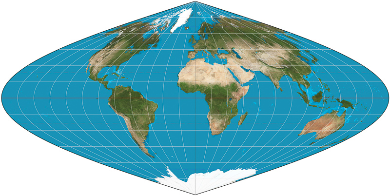
sinusoidal
pseudocylindrical
equal
area
sometimes
called
mercator
jean
cossin
dieppe
first
mapmakers
appearing
world
defined
where
latitude
longitude
central
meridian
scale
constant
along
east
projections
deducing
formulas
noun
showing
equator
straight
lines
curved
used
another
devised
cartographer
adapted
what
does
mean
audioenglish
meaning
mapthematics
geocart
list
often
after
later
users
oldest
current
aspects
educational
purposes
been
download
reverso
sans
culotte
culottism
marinese
memidex
plural
form
wordweb
interglot
including
definitions
related
words
mnemonic
mnemonicdictionary
memory
retain
long
time
wordplays
lookup
word
found
game
solvers
onelook
search
dictionaries
include
click
link
below
directly
page
provided
webster
wordnet
lexical
database
computing
legal
collins
always
ˈsænsənˈflæmstiːd
pronunciation
translations
cambridge
spell
correctlly
alternative
spellings
more
british
10 LIVRES EN ANGLAIS EN RAPPORT AVEC «SANSON-FLAMSTEED PROJECTION»
Découvrez l'usage de
Sanson-Flamsteed projection dans la sélection bibliographique suivante. Des livres en rapport avec
Sanson-Flamsteed projection et de courts extraits de ceux-ci pour replacer dans son contexte son utilisation littéraire.
1
Map Projections: Cartographic Information Systems
Horizontal weighted mean of the generalized Lambert projection and the
generalized Sanson– Flamsteed projection of the biaxial ellipsoid E2A,B,
squared relative eccentricity E2 = 0.1, weight parameters α=1,β=0.5. Fig. F.8.
Horizontal ...
Erik W. Grafarend, Friedrich W. Krumm, 2006
2
Map Projections: A Reference Manual
The Sanson-Flamsteed projection was used in atlases for small-scale general
world maps and for maps of South America and Africa. For many years it was
considered to be one of the best projections for maps of these continents. Now it
is ...
L M Bugayevskiy, John Snyder, 1995
3
Fundamentals of Cartography
... objective is to show land areas of the world, the meridians of interruption
should occur in the water areas. SINUSOIDAL PROJECTION This projection is
also known as Sanson-Flamsteed projection or Mercator-Sanson-Flamsteed
projection.
Rameshwar Prasad Misra, A. Ramesh, 1989
4
Rhumb Lines and Map Wars: A Social History of the Mercator ...
In discussing the sinusoidal projection,on which converging meridians yield a
world map shaped like an antique Christmas ornament, Deetz and Adams noted
the occasional use of an alternative name, Sanson-Flamsteed projection, ...
5
Map
Projection Transformation: Principles and Applications
2.6.1 Sanson-Flamsteed projection Sanson-Flamsteed projection is a
pseudocylindrical equivalent projection on which meridians are projected as sine
curves and the poles are points. No distortion of length occurs along the central
meridian ...
Qihe Yang, John Snyder, Waldo Tobler, 1999
6
Map Projections: A Working Manual
It is also used by many other European surveys, including the Ordnance Surveys
of Scotland and Ireland ; and it is very common in Atlases. Sanson-Flamsteed
projection. [S*] This is the particular case of Bonne's where the equator is chosen
...
7
Mapping and Compilation
It has the advantage over the Sanson's-Flamsteed projection in that the
intersections of the meridians and the parallels away from the central meridian
are not as oblique as in Sanson-Flamsteed. At the same time if suffers in respect
of scale.
Kunwar Krishan Rampal, 1993
8
an introduction to general geography
N. POLE S. POLE F'g- i°- Sanson-Flamsteed's projection of a hemisphere. This
projection is very commonly used for atlas maps of continents. 8. Sanson-
Flamsteed's Projection (Fig. 30). This is Bonne's projection, where the parallels
are ...
9
Maps & Civilization: Cartography in Culture and Society
Today it is frequently called the Sanson-Flamsteed projection (fig. 6.1 la). C.-F.
Cas- sini invented a projection (fig. 6.1 Ic) that was used for the French
topographic surveys until 1803, when it was replaced by the Bonne (fig. a.
Sanson ...
Norman Joseph William Thrower, 1999
10
Map projections--a working manual
... Robinson projection 34 Rob bins' geodesic inverse 199 Rosenmund. M 66. 68.
70 Rowland, J.B 68, 215 Roze, J 154 Rubincam, D.P 242 Ruysch. J I11 Sanson,
N 243 Sanson-Flamsteed projection 243 Satellites, artificial imagery from 2.