Téléchargez l'application
educalingo
Rechercher

Signification de "GIS" dans le dictionnaire anglais

Dictionnaire
DICTIONNAIRE
section

PRONONCIATION DE GIS EN ANGLAIS

GIS play
facebooktwitterpinterestwhatsapp

QUE SIGNIFIE GIS EN ANGLAIS

Cliquez pour voir la définition originale de «GIS» dans le dictionnaire anglais.
Cliquez pour voir la traduction automatique de la définition en français.
GIS

Système d'information géographique

Geographic information system

Un système d'information géographique est un système informatique conçu pour capturer, stocker, manipuler, analyser, gérer et présenter tous les types de données géographiques. L'acronyme GIS est parfois utilisé pour des études d'information géographique ou des études d'informations géospatiales pour se référer à la discipline académique ou à la carrière de travail avec les systèmes d'information géographique et est un domaine étendu dans la discipline académique plus large de Geoinformatics. Le SIG peut être considéré comme un système qui fournit des fonctions de saisie, de gestion, de récupération, d'analyse et de visualisation des données spatiales. La mise en œuvre d'un SIG repose souvent sur des exigences juridictionnelles, des objectifs ou des exigences d'application. Généralement, une implémentation SIG peut être personnalisée pour une organisation. Par conséquent, un déploiement GIS développé pour une application, une juridiction, une entreprise ou un but peut ne pas être nécessairement interopérable ou compatible avec un SIG qui a été développé pour une autre application, juridiction, entreprise ou but. Ce qui dépasse le SIG est une infrastructure de données spatiales, un concept qui n'a pas de frontières aussi restrictives. A geographic information system is a computer system designed to capture, store, manipulate, analyze, manage, and present all types of geographical data. The acronym GIS is sometimes used for geographical information science or geospatial information studies to refer to the academic discipline or career of working with geographic information systems and is a large domain within the broader academic discipline of Geoinformatics. GIS can be thought of as a system that provides spatial data entry, management, retrieval, analysis, and visualization functions. The implementation of a GIS is often driven by jurisdictional, purpose, or application requirements. Generally, a GIS implementation may be custom-designed for an organization. Hence, a GIS deployment developed for an application, jurisdiction, enterprise, or purpose may not be necessarily interoperable or compatible with a GIS that has been developed for some other application, jurisdiction, enterprise, or purpose. What goes beyond a GIS is a spatial data infrastructure, a concept that has no such restrictive boundaries.

définition de GIS dans le dictionnaire anglais

La définition de SIG dans le dictionnaire est un système d'information géographique: un système de stockage, d'édition et d'affichage d'informations géographiques sur ordinateur. Une autre définition du SRG est le supplément de revenu garanti.

The definition of GIS in the dictionary is geographic information system: a system for storing, editing, and displaying geographical information on computer. Other definition of GIS is guaranteed income supplement.

Cliquez pour voir la définition originale de «GIS» dans le dictionnaire anglais.
Cliquez pour voir la traduction automatique de la définition en français.

MOTS EN ANGLAIS COMMENÇANT COMME GIS

Girona
Gironde
Girondism
Girondist
gironny
girosol
girr
girsh
girt
girth
girtline
gisarme
Gisborne
Giscard d´Estaing
Gish
gism
gismo
Gissing

MOTS EN ANGLAIS FINISSANT COMME GIS

AFIS
AIS
CIS
DCIS
EFIS
EIS
FIS
NCIS
PSIS
UGLIS

Synonymes et antonymes de GIS dans le dictionnaire anglais de synonymes

SYNONYMES

MOTS EN ANGLAIS EN RAPPORT AVEC «GIS»

GIS jitsu clark county background check certification mass career jobs geographic information system computer designed capture store manipulate analyze manage present types geographical what esri integrates hardware software capturing managing analyzing displaying forms geographically summary general mills common stoc finance view basic stock chart change date range type compare against other companies grass home first release candidate improvements stability fixes stackexchange stack exchange question answer site cartographers geographers professionals nyse quotes news detailed financial including time historical charts november discovering world through event formalizes practice users vendors opening their doors schools businesses public showcase institute gisci exempt profit community diva simple effective program mapping make maps quote price today updated

Traducteur en ligne avec la traduction de GIS à 25 langues

TRADUCTEUR
online translator

TRADUCTION DE GIS

Découvrez la traduction de GIS dans 25 langues grâce à notre traducteur anglais multilingue.
Dans cette section, les traductions de GIS dans d'autres langues ont été obtenues par traduction automatique statistique, où l'unité essentielle de la traduction est le mot «GIS» en anglais.

Traducteur Français - chinois

地理信息系统
1325 millions de locuteurs

Traducteur Français - espagnol

GIS
570 millions de locuteurs

anglais

GIS
510 millions de locuteurs

Traducteur Français - hindi

जीआईएस
380 millions de locuteurs
ar

Traducteur Français - arabe

نظم المعلومات الجغرافية
280 millions de locuteurs

Traducteur Français - russe

ГИС
278 millions de locuteurs

Traducteur Français - portugais

GIS
270 millions de locuteurs

Traducteur Français - bengali

জিআইএস
260 millions de locuteurs

Traducteur Français - français

SIG
220 millions de locuteurs

Traducteur Français - malaisien

GIS
190 millions de locuteurs

Traducteur Français - allemand

GIS
180 millions de locuteurs

Traducteur Français - japonais

GIS
130 millions de locuteurs

Traducteur Français - coréen

GIS
85 millions de locuteurs

Traducteur Français - javanais

GIS
85 millions de locuteurs
vi

Traducteur Français - vietnamien

GIS
80 millions de locuteurs

Traducteur Français - tamoul

ஜிஐஎஸ்
75 millions de locuteurs

Traducteur Français - marathi

जीआयएस
75 millions de locuteurs

Traducteur Français - turc

CBS
70 millions de locuteurs

Traducteur Français - italien

GIS
65 millions de locuteurs

Traducteur Français - polonais

GIS
50 millions de locuteurs

Traducteur Français - ukrainien

ГІС
40 millions de locuteurs

Traducteur Français - roumain

GIS
30 millions de locuteurs
el

Traducteur Français - grec

GIS
15 millions de locuteurs
af

Traducteur Français - afrikaans

GIS
14 millions de locuteurs
sv

Traducteur Français - suédois

GIS
10 millions de locuteurs
no

Traducteur Français - norvégien

GIS
5 millions de locuteurs

Tendances d'usage de GIS

TENDANCES

TENDANCES D'USAGE DU TERME «GIS»

Le terme «GIS» est habituellement très utilisé et occupe la place 12.024 de notre liste de termes les plus utilisés du dictionnaire anglais.
0
100%
FRÉQUENCE
Très utilisé
95
/100
Sur la carte précédente est reflétée la fréquence d'utilisation du terme «GIS» dans les différents pays.
Tendances de recherche principales et usages générales de GIS
Liste des principales recherches réalisées par les utilisateurs pour accéder à notre dictionnaire anglais en ligne et des expressions les plus utilisées avec le mot «GIS».

FRÉQUENCE D'UTILISATION DU TERME «GIS» SUR LA PÉRIODE

Le graphique montre l'évolution annuelle de la fréquence d'utilisation du mot «GIS» durant les 500 dernières années. Son implémentation est basée sur l'analyse de la fréquence d'apparition du terme «GIS» sur les sources imprimées numériques anglaises publiées depuis l'année 1500 jusqu'aujourd'hui.

Exemples d'utilisation du mot GIS en anglais

EXEMPLES

10 LIVRES EN ANGLAIS EN RAPPORT AVEC «GIS»

Découvrez l'usage de GIS dans la sélection bibliographique suivante. Des livres en rapport avec GIS et de courts extraits de ceux-ci pour replacer dans son contexte son utilisation littéraire.
1
The GIS Book
"The GIS Book" features hands-on exercises enabling readers to use free GIS software and data downloaded over the Internet to gain a first-hand understanding of the power of GIS technology today.
George Korte, 2001
2
GIS: A Visual Approach
This fully updated edition of Geographic Information Systems: A Visual Approach offers a comprehensive introduction to the application of GIS concepts.
Bruce Ellsworth Davis, 2001
3
Encyclopedia of GIS
The Encyclopedia of GIS provides a comprehensive and authoritative guide, contributed by experts and peer-reviewed for accuracy, and alphabetically arranged for convenient access.
Shashi Shekhar, Hui Xiong, 2008
4
Open Source GIS: A GRASS GIS Approach
With this third edition of Open Source GIS: A GRASS GIS Approach, we enter the new era of GRASS6, the first release that includes substantial new code developed by the International GRASS Development Team.
Markus Neteler, Helena Mitasova, 2007
5
GIS: A Computer Science Perspective
It overviews database system philosophy; describes database concepts eg storage, retrieval, architecture, conceptual modelling, and database querying.It then focuses on the characteristics of GIS, spatial data and spatial databases, ...
Michael F. Worboys, 1995
6
Arc hydro: GIS for water resources
Written for hydrologists, GIS specialists, and scientists from many disciplines who create computer models of water resources, this book presents an improved standard for creating and using data in hydrologic projects.
David R. Maidment, 2002
7
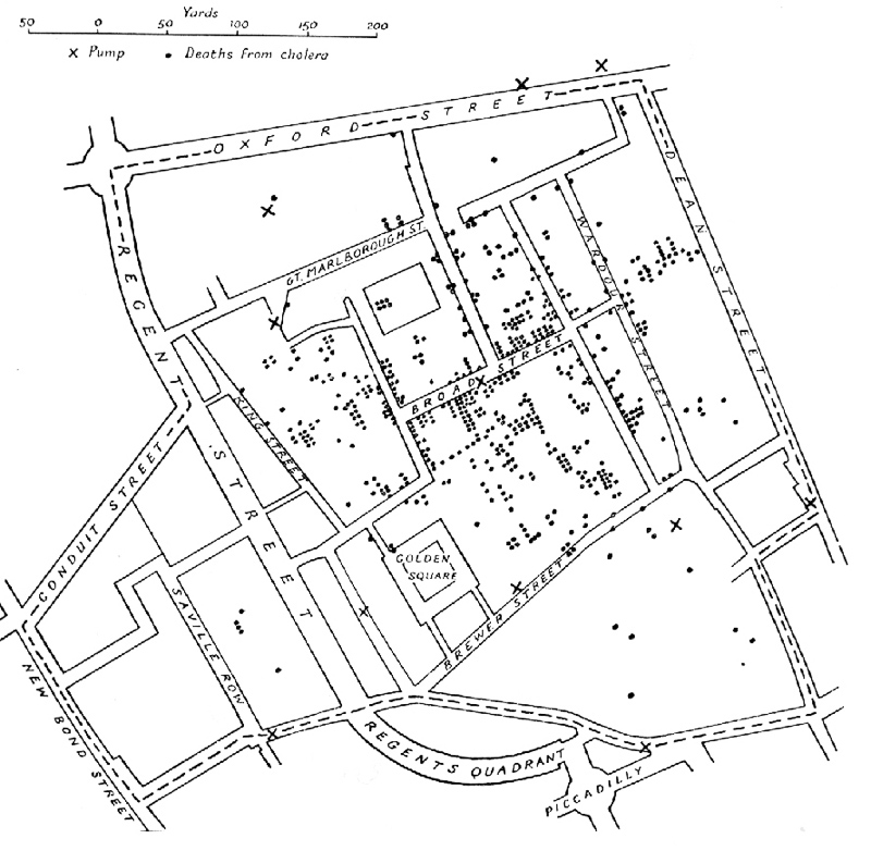
Historical GIS: Technologies, Methodologies, and Scholarship
Historical GIS is an emerging field that uses Geographical Information Systems (GIS) to research the geographies of the past.
Ian N. Gregory, Paul S. Ell, 2007
8
Building a GIS: System Architecture Design Strategies for ...
The book's reach is as broad as it is detailed, intended both for IT experts just now adopting the technology and for GIS experts just now getting into system design - and for the nontechnical executives who need to take advantage of ...
Dave Peters, 2008
9
GIS and Public Health
Authoritative and comprehensive, this is the leading text and professional resource on using geographic information systems (GIS) to analyze and address public health problems.
Ellen K. Cromley, Sara McLafferty, 2012
10
Spatial Databases: With Application to GIS
This book surveys various techniques, such as spatial data models, algorithms, and indexing methods, developed to address specific features of spatial data that are not adequately handled by mainstream DBMS technology.
Philippe Rigaux, Michel O. Scholl, Agnès Voisard, 2002

10 ACTUALITÉS CONTENANT LE TERME «GIS»

Découvrez de quoi on parle dans les médias nationaux et internationaux et comment le terme GIS est employé dans le contexte des actualités suivantes.
1
County GIS office earns award for Web application
ALBION — The Noble County Geographic Information System office has received an Excellence in GIS award in the county government sector ... «KPCnews.com, juil 15»
2
PepsiCo, General Mills Must Beware of These 3 Packaged-Food …
Get TheStreet Quant Ratings' exclusive 5-page report for (GIS) - FREE. ... as PepsiCo (PEP - Get Report) and General Mills (GIS - Get Report) ... «TheStreet.com, juil 15»
3
Analysts Set General Mills PT at $54.63 (NYSE:GIS)
General Mills logo General Mills (NYSE:GIS) has received an average rating of “Hold” from the ten brokerages that are covering the company, Analyst Ratings ... «Dakota Financial News, juil 15»
4
Brands That PepsiCo and General Mills Should Get Rid Of
With many consumers increasingly preferring to buy fresh organic produce, General Mills (GIS - Get Report), maker of Yoplait yogurt and ... «TheStreet.com, juil 15»
5
GIS and the Real Estate sector
Still, many real estate businesses do not fully understand how to maximize the benefits of location intelligence by using a GIS. There is an ... «Stabroek News, juil 15»
6
Esri Press Book Explores How GIS Tools Help to Manage and …
"All of this data combined, complemented by new GIS analytical and modeling technology and techniques, has provided humanity with a new ... «Spatial News, juil 15»
7
Fort Sam to lose 329 GIs in Army cuts
Army soldiers run at 5:30 a.m. Wednesday June 3, 2015 at Joint Base San Antonio-Fort Sam Houston after the American flag was raised and a ... «mySanAntonio.com, juil 15»
8
Will General Mills (GIS) Show Better Results in Fiscal 2016?
We issued an updated research report on General Mills, Inc. (GIS - Analyst Report) on Jul 8, 2015. On Jul 1, General Mills reported ... «Zacks.com, juil 15»
9
Dine Smart: MCHD offers GIS access to food facilities
The McDonough County Health Department's food facility updates are now easier to access, with help from Western Illinois University's GIS ... «McDonough Voice, juil 15»
10
Senior GIS Developer
GeoDecisions is currently seeking a Mid- to Senior Developer to work in either our Middletown, DE, or Philadelphia, PA offices. The Mid- to ... «Technical.ly, juil 15»
RÉFÉRENCE
« EDUCALINGO. Gis [en ligne]. Repéré à <https://educalingo.com/fr/dic-en/gis>. Mai 2024 ».
Téléchargez l'application educalingo
en
dictionnaire anglais
Découvrez tout ce que les mots cachent sur
index
a b c d e f g h i j k l m n o p q r s t u v w x y z