Undhuh app
educalingo
Golèki

Tegesé saka "isopach" ing bausastra Basa Inggris

Bausastra
BAUSASTRA
section

ETIMOLOGI SAKA TEMBUNG ISOPACH

From iso- + Greek pakhus thick, pakhutēs thickness.
info
Etymology pasinaon babagan asliné tembung lan owahané ing wangun lan teges.
facebooktwitterpinterestwhatsapp
section

PANGOCAP SAKA ISOPACH ING BASA INGGRIS

isopach  [ˈaɪsəʊˌpæk] play
facebooktwitterpinterestwhatsapp

GOLONGAN PARAMASASTRA SAKA ISOPACH

tembung aran
tembung sipat
tembung kriya
tembung katrangan
tembung ganti
preposition
panyambung
panemtu
seru

APA TEGESÉ ISOPACH ING BASA INGGRIS?

Klik kanggo deleng deifinisi asli saka «isopach» ing bausastra Basa Inggris.
Klik kanggo deleng pertalan otomatis saka definisi ing Basa Jawa.
isopach

Isopach map

Isopach map

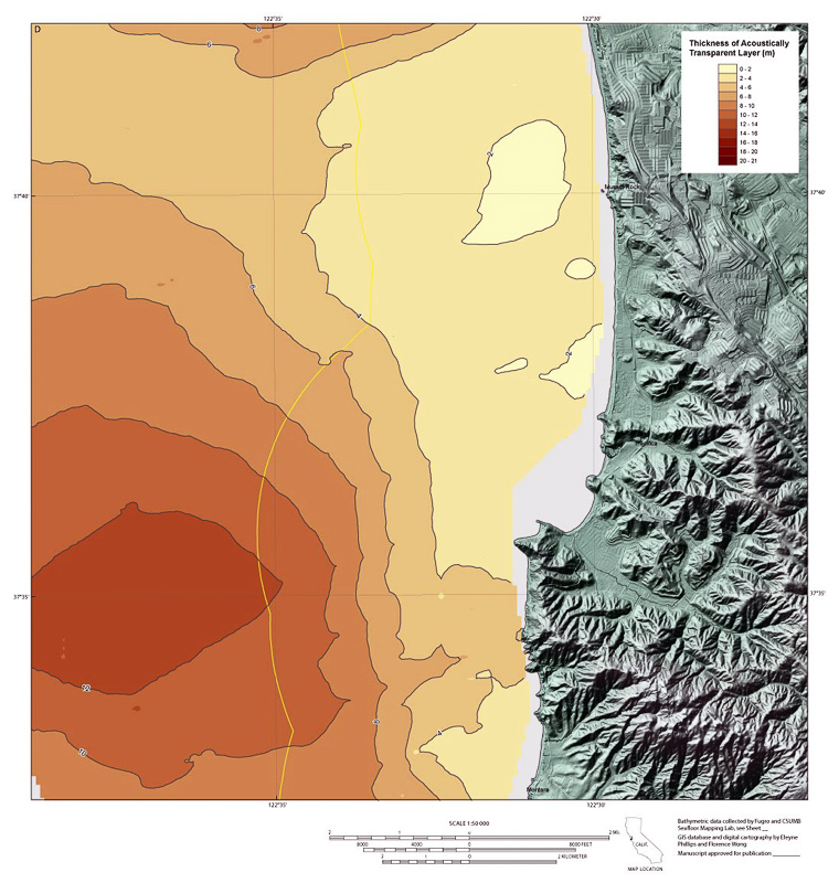
Peta isopach nggambarake variasi ketebalan ing unit tabel, lapisan utawa stratum. Isopachs minangka garis kontur sing jembaré sajrone wilayah. Peta Isopach digunakake ing survey hidrografi, stratigrafi, sedimentologi, geologi struktural, geologi petroleum, lan vulkanologi. Peta isopach mirip karo peta isochore, nanging istilah kasebut nerangake cara sing beda kanggo nampilake variasi ketebalan ing lapisan. ▪ Peta isopach nampilake garis-garis sing padha karo kekandelan ing lapisan endi endhek sing diukur tegese jejeg lapisan. Isopach peta ing geologi uga disebut minangka peta Tebal Stratigraphic Sejati. ▪ Peta isochore nampilake garis-garis ketebalan sing padha ing lapisan ing endi ketebalan diukur vertikal. Peta geosains ing geologi uga diarani peta Bujur Vertikal. Mangkono, peta isochore lan isopach mung padha nalika lapisan ndhuwur lan ngisor lapisan sing ditampilake horisontal. Nalika lapisan sing ditampilake cenderung, kaya biasane, ketebalan sing ditampilake ing peta isochore lapisan bakal luwih dhuwur tinimbang tebal sing ditampilake ing peta isopach lapisan sing padha. An isopach map illustrates thickness variations within a tabular unit, layer or stratum. Isopachs are contour lines of equal thickness over an area. Isopach maps are utilized in hydrographic survey, stratigraphy, sedimentology, structural geology, petroleum geology and volcanology. An isopach map is similar to an isochore map, but these terms actually describe different methods of displaying thickness variations within a layer. ▪ An isopach map displays lines of equal thickness in a layer where the thicknesses are measured perpendicular to the layer boundaries. Isopach maps in geology are also referred to as True Stratigraphic Thickness maps. ▪ An isochore map displays lines of equal thickness in a layer where the thicknesses are measured vertically. Isochore maps in geology are also referred to as True Vertical Thickness maps. Thus, an isochore and isopach map are the same only when both the top and bottom surfaces of the layer shown are horizontal. When the layer shown is inclined, as is usually the case, the thicknesses displayed in an isochore map of the layer will be greater than the thicknesses displayed in an isopach map of the same layer.

Definisi saka isopach ing bausastra Basa Inggris

Definisi isopach ing kamus iku baris ing peta sing nyambung titik-titik ing ngisor iki sing tumpukan batu tartamtu nduweni ketebalan sing padha.

The definition of isopach in the dictionary is a line on a map connecting points below which a particular rock stratum has the same thickness.

Klik kanggo deleng deifinisi asli saka «isopach» ing bausastra Basa Inggris.
Klik kanggo deleng pertalan otomatis saka definisi ing Basa Jawa.

TEMBUNG BASA INGGRIS KANG KALARAS PADHA KARO ISOPACH


backpack
ˈbækˌpæk
bipack
ˈbaɪˌpæk
bratpack
ˈbrætˌpæk
Britpack
ˈbrɪtˌpæk
gopak
ˈɡəʊˌpæk
handy-pack
ˈhændɪˌpæk
hardpack
ˈhɑːdˌpæk
manpack
ˈmænˌpæk
mudpack
ˈmʌdˌpæk
multipack
ˈmʌltɪˌpæk
portapack
ˈpɔːtəˌpæk
ratpack
ˈrætˌpæk
retropack
ˈrɛtrəʊˌpæk
shoepac
ˈʃuːˌpæk
shoepack
ˈʃuːˌpæk
shrinkpack
ˈʃrɪŋkˌpæk
snowpack
ˈsnəʊˌpæk
tripack
ˈtraɪˌpæk
woolpack
ˈwʊlˌpæk

TEMBUNG BASA INGGRIS KANG AWIT KAYA ISOPACH

isooctane
isopachyte
isoperimeter
isoperimetrical
isoperimetry
isophone
isophotal
isophote
isopiestic
isopiestically
isopleth
isoplethic
isopluvial
isopod
isopodan
isopodous
isopolity
isoprenaline
isoprene
isoprenoid

TEMBUNG BASA INGGRIS KANG WUSANANÉ KAYA ISOPACH

ach
approach
attach
bach
beach
bleach
breach
coach
each
Long Beach
Mach
nach
outreach
Palm Beach
peach
reach
Sempach
stomach
stroupach
teach

Dasanama lan kosok bali saka isopach ing bausastra dasanama Basa Inggris

DASANAMA

Pertalan saka «isopach» menyang 25 basa

PAMERTAL
online translator

PERTALAN SAKA ISOPACH

Weruhi pertalan saka isopach menyang 25 basa nganggo Basa Inggris pamertal multi basa kita.
pertalan saka isopach saka Basa Inggris menyang basa liyané kang kasuguhaké ing perangan iki kajupuk saka pertalan statistik otomatis; ing ngendhi inti unit pertalan yaiku tembung «isopach» ing Basa Inggris.

Pamertal Basa Inggris - Basa Cina

等厚线
1,325 yuta pamicara

Pamertal Basa Inggris - Basa Spanyol

isopaca
570 yuta pamicara

Basa Inggris

isopach
510 yuta pamicara

Pamertal Basa Inggris - Basa India

isopach
380 yuta pamicara
ar

Pamertal Basa Inggris - Basa Arab

خط تساوي العمق
280 yuta pamicara

Pamertal Basa Inggris - Basa Rusia

изопахит
278 yuta pamicara

Pamertal Basa Inggris - Basa Portugis

isópacas
270 yuta pamicara

Pamertal Basa Inggris - Basa Bengali

isopach
260 yuta pamicara

Pamertal Basa Inggris - Basa Prancis

isopaque
220 yuta pamicara

Pamertal Basa Inggris - Basa Malaysia

Isopach
190 yuta pamicara

Pamertal Basa Inggris - Basa Jerman

Isopache
180 yuta pamicara

Pamertal Basa Inggris - Basa Jepang

等層厚線
130 yuta pamicara

Pamertal Basa Inggris - Basa Korea

isopach
85 yuta pamicara

Pamertal Basa Inggris - Basa Jawa

Isopach
85 yuta pamicara
vi

Pamertal Basa Inggris - Basa Vietnam

isopach
80 yuta pamicara

Pamertal Basa Inggris - Basa Tamil

isopach
75 yuta pamicara

Pamertal Basa Inggris - Basa Marathi

समस्थानिक
75 yuta pamicara

Pamertal Basa Inggris - Basa Turki

İzopak
70 yuta pamicara

Pamertal Basa Inggris - Basa Italia

isopach
65 yuta pamicara

Pamertal Basa Inggris - Basa Polandia

isopach
50 yuta pamicara

Pamertal Basa Inggris - Basa Ukrania

ізопахіт
40 yuta pamicara

Pamertal Basa Inggris - Basa Romawi

isopach
30 yuta pamicara
el

Pamertal Basa Inggris - Basa Yunani

isopach
15 yuta pamicara
af

Pamertal Basa Inggris - Basa Afrikaans

isopach
14 yuta pamicara
sv

Pamertal Basa Inggris - Basa Swedia

isopach
10 yuta pamicara
no

Pamertal Basa Inggris - Basa Norwegia

isopach
5 yuta pamicara

Trèn migunakaké isopach

TRÈN

KEKAREPAN PANGGUNAN ARAN «ISOPACH»

0
100%
ARANG KEREPÉ
Sethithik digunakaké
37
/100
Kart kang kapituduh ing dhuwur nuduhaké arang kerepé kagunané aran «isopach» ing negara kang béda-béda.
Dhasar kekarepan panggolékan lan kagunaan kang umum saka isopach
Daptar dhasar panggolékan kang dilakoni dening pangguna kanggo migunakaké Basa Inggris bausastra online kita lan gupita kang asring digunakaké nganggo tembung «isopach».

ARANG KEREPÉ PANGGUNANÉ ARAN «ISOPACH» SALAWASÉ IKI

Gambar awujudaké arang kerepé evolusi taunan panggunané saka tembung «isopach» sasuwiné 500 taun. Panggunané andedhasar panalitén sapira asringé aran «isopach» metu ing sumber kang kacé digital ing Basa Inggris antaraning taun 1500-an lan wektu iki.

Tuladha kang kagunakaké ing sastra Basa Inggris, pethikan lan warta babaganisopach

TULADHA

BUKU BASA INGGRIS KAKAIT KARO «ISOPACH»

Temukaké kagunané saka isopach ing pilihan bibliografi iki. Buku kang kakait dening isopach lan pethikan cekak kang padha kanggo nyediyakaké panggunané ing sastra Basa Inggris.
1
Nontechnical Guide to Petroleum Geology, Exploration, ...
Isopach map An isopach map (fig. 8–14) uses contour lines to show the thickness ofa subsurface layer. If an oil or gas field has been drilled, an isopach map can be made ofthe reservoir rock pay zone. The pay zone is the vertical distance in a  ...
Norman J. Hyne, 2012
2
3-D Structural Geology: A Practical Guide to Quantitative ...
or errors in the dip may appear as thickness anomalies. An isopach map is a map of the true thickness of the unit (t, Fig. 4.1) measured normal to the unit boundaries (Bates and Jackson 1987). An isocore map is defined as a map of the vertical ...
Richard H. Groshong, 2006
3
Main Types of Geological Maps: Purpose, Use and Preparation
This map can give an idea of the structural features of a deeper level (example: an isopach of a formation of the Cretaceous can give a palaeostructural image of the Dogger). Detailed study The larger the scale, the higher the density of control  ...
Margaret Majithia, 1997
4
Handbook of Geophysical Exploration at Sea
The western portion of the map shows an isopach thick to the north as did the Interval I isopach. However, the zone of maximum thickness had migrated slightly to the west during Interval I-Interval II time. The most prominant difference between ...
Richard A. Geyer, Margaret Ashwell, 1991
5
New Zealand Journal of Geology and Geophysics
The thickness measurements on which Vucetich & Pullar's isopach map were based included a substantial amount of Te Rato Lapilli material in the paleosol on Karapiti Tephra (C. G. Vucetich pers. comm. 1983). New data east and south of ...
6
Mineral resource potential and geology of the Routt National ...
A. Isopach map of cumulative coal in the lles Formation in and near Area l 8l B. Isopach map of overburden; datum is top of lles Formation in Area l 8l 33. A. Isopach map of cumulative coal in the Williams Fork Formation in and near Area l 84 ...
Viki Bankey, Sandra J. Soulliere, Margo I. Toth, 2000
7
Geologic Controls and Reservoir Characterization of the ...
The units for all isopach maps are in feet and the contour interval varies from one isopach map to another. For the Lower Oneida Sandstone isopach (Figure 15) I used a contour interval of 5 feet (1.524 m) and connected the contours from the ...
Khurrum Ahmed, 2008
8
The Supai Group of Grand Canyon
Thickness and paleogeographic map, Permian. Isopach map, Pennsylvanian. Isopach map, Permian. Major late Paleozoic tectonic elements. Northern Arizona isopach map, Pennsylvanian. Thickness of pre-Paradox Pennsylvanian rocks.
Edwin Dinwiddie McKee, 1982
9
Geological Survey Bulletin
Page 12. Isopach map of the mudstone and siltstone unit of the Chinle formation 31 13. Isopach map of the Wingate sandstone 33 14. Isopermeability map of the Wingate sandstone 34 15. Isotransmissivity map of the Wingate sandstone 35 16  ...
‎1949
10
Geological Survey Professional Paper
Owing to extensive cover by younger units, data on the thickness of the Crater Flat are spotty, and many thicknesses shown on the isopach maps (figs. 11, 14, and 15) are minima. There is enough control, however, to show that the thickest part ...
Geological Survey (U.S.), 1986

BABAGAN WARTA KANG NGLEBOKAKÉ ARAN «ISOPACH»

Weruhi yèn pawarta nasional lan internasional wis ngomongaké lan kepriyé aran isopach digunakaké ing babagan warta iki.
1
Updated geologic maps provide greater detail for Marcellus formation
To generate formation structure and thickness (isopach) maps, EIA uses stratigraphic correlations provided by state geological survey agencies ... «OilVoice, Apr 15»
2
An Underexplored Hydrocarbon Province
Regional mapping of the distribution of the BSR shows a strong correlation with an isopach thick that defines the Rio Grande Cone depocenter. «E&P, Apr 15»
3
Bakken Update: Continental Resources' Well Results Around 2 …
The middle Bakken isopach shows us how thick the interval is throughout North Dakota. The green areas are the thickest and should be ... «Seeking Alpha, Des 14»
4
Bakken Update: 2015 May Be A Difficult Year For This Bakken Non …
The Isopach above shows where the thickest middle Bakken interval is. The darker the area, the thicker the shale. At its maximum, we see over ... «Seeking Alpha, Nov 14»
5
Land for Shale
Duvernay Formation net shale isopach with thicker net shale identified by darker red to blue map colours. The two main areas of activity focus ... «Pipeline News North, Agus 14»
6
Trinity Valley Increases Reserve Base At Days Chapel
This interim report contains an increased estimate to 16,621,771 barrels of original oil in place at Days Chapel to the Isopach zero foot contour ... «MarketWatch, Feb 14»
7
EurekaMag.com Publishes 1874 New Articles on Geologic Mapping
... on isopach maps detail the variations in thickness of stratigraphic units. It includes summaries on geologic mapping of the Ladakh Himalaya ... «PR Web, Feb 14»
8
Bakken Update's 2014 Bakken Stock Picks: The Bakken Operators …
When we take the middle Bakken isopach and compare to the Three Forks group, we find both are good in roughly the same area. What is ... «Seeking Alpha, Jan 14»
9
Forest Oil Corporation (FST): Forest Oil: Why This $3 Oil Stock Might …
I would suggest beginning the analysis with isopach maps showing the thickness of the EF shale where FST's has their assets. Then look at the ... «Seeking Alpha, Des 13»
10
Range Resources evaluating coal seam gas drilling following …
This was calculated using the isopach maps for the Upper Bathonian coaly section, which covers 368 square kilometres and 83 square ... «Proactive Investors Australia, Sep 13»
KAITAN
« EDUCALINGO. Isopach [online]. Kasedya <https://educalingo.com/jv/dic-en/isopach>. Mei 2024 ».
Undhuh app educalingo
en
Basa Inggris bausastra
Temukaké kabèh kang dhelik ing tembung ana ing
indeks
a b c d e f g h i j k l m n o p q r s t u v w x y z