«ISOPACH» 관련 영어 책
다음 도서 목록 항목에서
isopach 의 용법을 확인하세요.
isopach 에 관련된 책과 해당 책의 짧은 발췌문을 통해 영어 서적에서 단어가 사용되는 맥락을 제공합니다.
1
Nontechnical Guide to Petroleum Geology, Exploration, ...
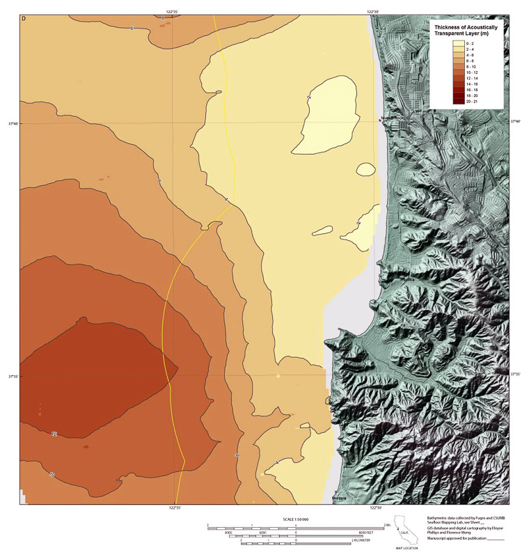
Isopach map An isopach map (fig. 8–14) uses contour lines to show the thickness
ofa subsurface layer. If an oil or gas field has been drilled, an isopach map can
be made ofthe reservoir rock pay zone. The pay zone is the vertical distance in a
...
2
3-D Structural Geology: A Practical Guide to Quantitative ...
or errors in the dip may appear as thickness anomalies. An isopach map is a map
of the true thickness of the unit (t, Fig. 4.1) measured normal to the unit
boundaries (Bates and Jackson 1987). An isocore map is defined as a map of the
vertical ...
Richard H. Groshong, 2006
3
Main Types of Geological Maps: Purpose, Use and Preparation
This map can give an idea of the structural features of a deeper level (example:
an isopach of a formation of the Cretaceous can give a palaeostructural image of
the Dogger). Detailed study The larger the scale, the higher the density of control
...
4
Handbook of Geophysical Exploration at Sea
The western portion of the map shows an isopach thick to the north as did the
Interval I isopach. However, the zone of maximum thickness had migrated slightly
to the west during Interval I-Interval II time. The most prominant difference
between ...
Richard A. Geyer, Margaret Ashwell, 1991
5
New Zealand Journal of Geology and Geophysics
The thickness measurements on which Vucetich & Pullar's isopach map were
based included a substantial amount of Te Rato Lapilli material in the paleosol
on Karapiti Tephra (C. G. Vucetich pers. comm. 1983). New data east and south
of ...
6
Mineral resource potential and geology of the Routt National ...
A. Isopach map of cumulative coal in the lles Formation in and near Area l 8l B.
Isopach map of overburden; datum is top of lles Formation in Area l 8l 33. A.
Isopach map of cumulative coal in the Williams Fork Formation in and near Area l
84 ...
Viki Bankey, Sandra J. Soulliere, Margo I. Toth, 2000
7
Geologic Controls and Reservoir Characterization of the ...
The units for all isopach maps are in feet and the contour interval varies from one
isopach map to another. For the Lower Oneida Sandstone isopach (Figure 15) I
used a contour interval of 5 feet (1.524 m) and connected the contours from the ...
8
The Supai Group of Grand Canyon
Thickness and paleogeographic map, Permian. Isopach map, Pennsylvanian.
Isopach map, Permian. Major late Paleozoic tectonic elements. Northern Arizona
isopach map, Pennsylvanian. Thickness of pre-Paradox Pennsylvanian rocks.
Edwin Dinwiddie McKee, 1982
9
Geological Survey Bulletin
Page 12. Isopach map of the mudstone and siltstone unit of the Chinle formation
31 13. Isopach map of the Wingate sandstone 33 14. Isopermeability map of the
Wingate sandstone 34 15. Isotransmissivity map of the Wingate sandstone 35 16
...
10
Geological Survey Professional Paper
Owing to extensive cover by younger units, data on the thickness of the Crater
Flat are spotty, and many thicknesses shown on the isopach maps (figs. 11, 14,
and 15) are minima. There is enough control, however, to show that the thickest
part ...
Geological Survey (U.S.), 1986
«ISOPACH» 단어를 포함하는 뉴스 기사
다음 뉴스 기사의 맥락에서 국내 및 국제 언론이 말하는 내용 및
isopach 단어를 사용하는 방법을 알아보세요.
Updated geologic maps provide greater detail for Marcellus formation
To generate formation structure and thickness (isopach) maps, EIA uses stratigraphic correlations provided by state geological survey agencies ... «OilVoice, 4월 15»
An Underexplored Hydrocarbon Province
Regional mapping of the distribution of the BSR shows a strong correlation with an isopach thick that defines the Rio Grande Cone depocenter. «E&P, 4월 15»
Bakken Update: Continental Resources' Well Results Around 2 …
The middle Bakken isopach shows us how thick the interval is throughout North Dakota. The green areas are the thickest and should be ... «Seeking Alpha, 12월 14»
Bakken Update: 2015 May Be A Difficult Year For This Bakken Non …
The Isopach above shows where the thickest middle Bakken interval is. The darker the area, the thicker the shale. At its maximum, we see over ... «Seeking Alpha, 11월 14»
Land for Shale
Duvernay Formation net shale isopach with thicker net shale identified by darker red to blue map colours. The two main areas of activity focus ... «Pipeline News North, 8월 14»
Trinity Valley Increases Reserve Base At Days Chapel
This interim report contains an increased estimate to 16,621,771 barrels of original oil in place at Days Chapel to the Isopach zero foot contour ... «MarketWatch, 2월 14»
EurekaMag.com Publishes 1874 New Articles on Geologic Mapping
... on isopach maps detail the variations in thickness of stratigraphic units. It includes summaries on geologic mapping of the Ladakh Himalaya ... «PR Web, 2월 14»
Bakken Update's 2014 Bakken Stock Picks: The Bakken Operators …
When we take the middle Bakken isopach and compare to the Three Forks group, we find both are good in roughly the same area. What is ... «Seeking Alpha, 1월 14»
Forest Oil Corporation (FST): Forest Oil: Why This $3 Oil Stock Might …
I would suggest beginning the analysis with isopach maps showing the thickness of the EF shale where FST's has their assets. Then look at the ... «Seeking Alpha, 12월 13»
Range Resources evaluating coal seam gas drilling following …
This was calculated using the isopach maps for the Upper Bathonian coaly section, which covers 368 square kilometres and 83 square ... «Proactive Investors Australia, 9월 13»


