KSIĄŻKI POWIĄZANE ZE SŁOWEM «MERCATOR'S PROJECTION»
Poznaj użycie słowa
Mercator's projection w następujących pozycjach bibliograficznych Książki powiązane ze słowem
Mercator's projection oraz krótkie ich fragmenty w celu przedstawienia kontekstu użycia w literaturze.
1
Rhumb Lines and Map Wars: A Social History of the Mercator ...
In Rhumb Lines and Map Wars, Mark Monmonier offers an insightful, richly illustrated account of the controversies surrounding Flemish cartographer Gerard Mercator's legacy.
This suggests Mercator's projection. The magnetic meridians17 are not
coincident with the geographical meridians, however, so that a magnetic error
should exist on the maps. A difference between "rose north" and true north can in
fact be ...
3
Small-Scale Map
Projection Design
Since Mercator's projection is conformal all indicatrices are circles. However, as
can be seen, the area of the circles increases with increasing latitude, indicating
a strong variation in principal and areal scale factors. On the equator, which is a ...
4
The Penny Cyclopædia of the Society for the Diffusion of ...
... the head Mercator's Projection. See also Map, and Stereographic,
Orthographic, Gno- monic, and Conical Projections, under which last head look
for Flamsteed's and the modern French projections. CHARTA, MAGNA. [Magna
Charta.] ...
5
Old World, New World: Great Britain and America from the ...
... bearing was crucial for navigation across the ocean, where many days were
spent sailing out of sight of land.-0 Mercator's projection provided, in principle, a
sound basis for navigation and for recording locations discovered by exploration.
6
The penny cyclopædia [ed. by G. Long].
Mercator's Projection. — The line on which a ship sails, when directing her
course obliquely to the meridian, is on the globe a spiral, since it cuts all the
meridians throuch which it passes at equal angles. This circumstance, combined
with ...
Society for the diffusion of useful knowledge, George Long, 1839
7
Globalization, Language, and Culture
Again,recall that maps are always purpose-driven: Mercator's projection was
designed for navigational purposes, and it fulfills that purpose beautifully.
However, it necessarily distorts the relative sizes of landmasses in fulfilling its
purpose.
8
Elements of Geography, Ancient and Modern: With an Atlas
To draw a map of the world on Mercator's projection. (See fig. 5, plate II.) Lay out
the map in any size that may be wanted. Draw the line E VV to represent the.
Equator, and the line N S for a meridian of longitude. Draw right lines parallel to
the ...
Joseph Emerson Worcester, 1822
... that are accepted as beyond dispute for the first reason only are like those
features of a terrestrial map that depend only on the mode of projection by which
the map was produced: such as the fact that, in a map drawn to Mercator's
projection ...
Robert S. Cohen, Thomas Schnelle, Ludwik Fleck, 1986
10
Mathematical Thought From Ancient to Modern Times
5) stem from Ptolemy, and Mercator's projection (Chap. 12, sec. 2) dates from the
sixteenth century. It may have been intuitively clear prior to the eighteenth century
that no true map of a sphere could be made on a plane, that is, one cannot ...
WIADOMOŚCI, KTÓRE ZAWIERAJĄ SŁOWO «MERCATOR'S PROJECTION»
Sprawdź, o czym dyskutuje się w prasie krajowej i zagranicznej oraz jak jest stosowane słowo
Mercator's projection w wiadomościach.
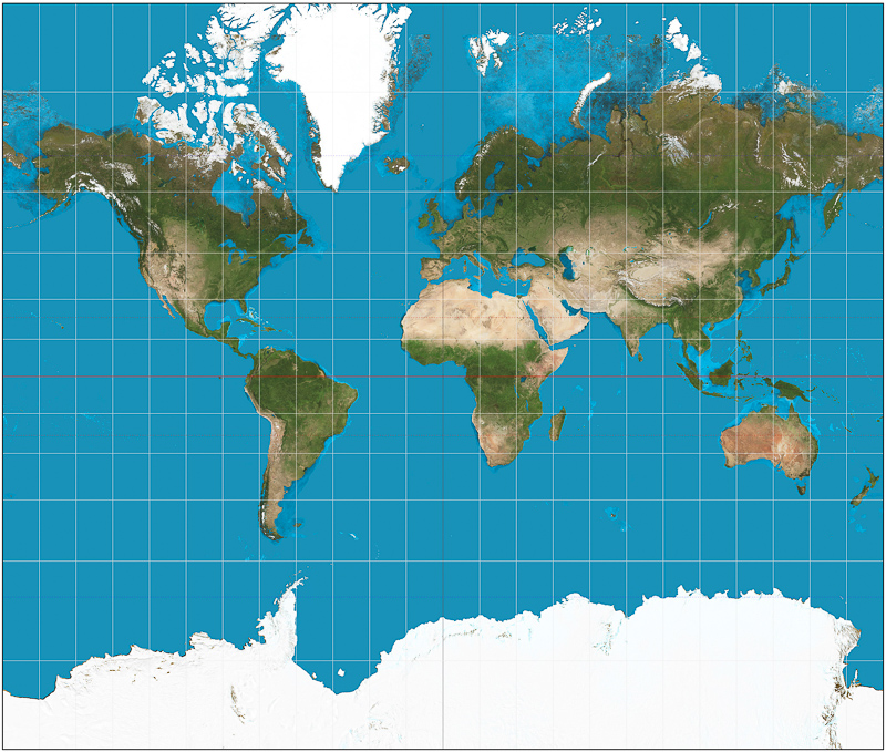
There's no perfect map but Mercator's is marvellous
On Mercator's projection, all parallels of latitude have equal length. Since on Earth their lengths decrease towards the poles, the parallels are ... «Irish Times, Maj 15»
Scarborough is Phl, antique maps show (2)
(23) “East India Islands on Mercator's Projection,” by Thomas Kelly, was published between 1814 and 1832 in London. It shows “Scarboro” ... «Philippine Star, Paz 14»
Putting 'Australia' on the map
... there are exceptions, such as the delineations on several world maps from Dutch Golden Age which are based on Mercator's projection. «The Conversation, Sie 14»
8 Surprising Facts That Will Make You Rethink the True Size of …
The most popular map projection, Mercator's projection, was developed by a Flemish cartographer and originally used as a nautical chart to aid ... «Atlanta Black Star, Sie 14»
David Adjaye interview: 'I'm not always looking at the usual references'
They collectively offer the same reorientation as those world maps that dispense with the Eurocentric bias of Mercator's projection. The location ... «The Guardian, Sie 14»
The Mapmaker's Conundrum
In world maps drawn using Mercator's projection, the one that served as the standard in atlases for centuries, the equatorial areas pan out fine, ... «New Yorker, Lip 14»
The Secret, Contentious History of Maps
“To those used to Mercator's projection, the northern continents (in Peters's map) appeared radically reduced in size,” Jerry Brotton writes in A ... «Daily Beast, Lis 13»
A History of the World in Twelve Maps by Jerry Brotton: review
This world map was produced by the German historian Arno Peters, who fiercely denounced the traditional system, Mercator's projection, ... «Telegraph.co.uk, Wrz 12»
Happy Bloomsday 2012: Celebrate with Guinness, Offal + Water
... its own level: its vastness in the ocean of Mercator's projection: its umplumbed profundity in the Sundam trench of the Pacific exceeding 8,000 ... «LA Weekly, Cze 12»
The art of travel
Today, Mercator's Projection is used by the Ordnance Survey to map Britain, by Nasa to map the solar system, and for numerous other ... «Financial Times, Cze 12»